Project title: Knowledge integration and Management Strategy Evaluation modelling
Program: Kimberley Marine Research Program
Modelling the future of the Kimberley region
The Models
In this project, the Management Strategy Evaluation has been carried out via two computer models: ALCES and Ecopath with Ecosim (EwE). The purpose of using these models is to integrate existing and new knowledge about the Kimberley system and to provide an estimation of the likely impacts of different stressors on the land (ALCES) and marine (EwE) environments.
Before the models can start answering management questions, the models need to be set up for this project's specific needs. This involves mostly three interrelated steps:
- the model domain need to be chosen (this defines what is ‘internal’ vs ‘external’ to our system)
- the models need to be parameterised (we need to provide the model information about the system) and
- the models’ structure has to be defined (this defines what components of the system we include).
These steps require expertise and technical knowledge but also experience and good judgement. They define what is often called ‘the art of modelling’.
A model domain represents the geographical area covered by the model. The borders of the domain thus discriminate between what spatial features are ‘internal’ or ‘external’ to the model. The choice of the model domain thus reflects what we treat as internal and external to the Kimberly system. This choice is problem-specific. It depends on type of questions we need to answer and what processes are relevant to those questions. It also depends on technical issues related to the characteristics of the models we use, the computational effort they require and the level of model complexity we are willing to accept.
In addition, workflow constraints are critical. While ideally we would like to be able to change the model domain according to how the project develops and what questions become relevant when more information is made available, in practise this is rarely possible, since all model implementation steps depend on the model domain. As a result this choice has to be finalised early in a modelling project. Similar considerations apply to the models’ structure.
The models' parameterisation has been carried out independently by the Alces and EwE modelling teams. A model parameterisation takes currently available information about the state of the Kimberley system and codifies it in a way that can be used by a computer model. The role of this step is at times misunderstood and undervalued. Three concepts are particularly important not only for this modelling project that for the overall Kimberly research effort. First, the outcome of a model parameterisation is not just a model input but also a snapshot of what we know about the system. The actual extent of this knowledge is often laid bare by the very process of model parameterisation. The need to provide a model with a numerical value for (say) turtle biomass and age structure forces the modellers to look for and certify this information if available and to extrapolate credible ranges from other sources if not available. Often it is not until this process needs to be carried out that the extent of our (lack of) knowledge is made clear. In Donald Rumsfel’s parlance, this process turns some data gaps from ‘unknown unknowns’ into known ones Second, since data collection always needs to be prioritised, model sensitivity analysis may provide information on what type of information could provide the largest impact on management-relevant knowledge. Third, the existence of large data gaps at times leads critics to question the value and reliability of a modelling effort. This overlooks the fact that ultimately decisions will have to be made even in the presence of data gaps. Rather than being invalidated by large data gaps, modelling provides a way to recognise, formalise and evaluate the relative impacts of these data gaps.
Model integration
Finally, the the models’ structure affects the communication between the two models, which represents the interaction between terrestrial and marine environments and is crucial to fully integrate ecological, social and economic data. Within the approach we described here, the computer models aim to describe our understanding of the state of the Kimberley system as it is now and how it functions, since both are essential for us to say something useful about what may happen to the system in the future.
This means that
- underlying the Alces model there is a conceptual model on how the Kimberley land environment works
- underlying the EwE model there is a conceptual model on how the Kimberley marine environment works, and
- underlying the interaction between the Alces and EwE Alces models there is a conceptual model on how the land and marine environments interface.
Below, we briefly describe these conceptual models and how they interact.
On the left hand side of Figure 1, we can see a simple formulation of the conceptual model representing land processes in the Kimberley region. Land processes are dominated by a number of natural processes (geology, hydrology, climate) and by a number of sectors including settlements, mining, energy, croplands, livestock, tourism, and transportation. In turns, these are affected by and affect, population growth and economic activities.
These land based processes affect the marine environment via a number of stressors on the coastal environment (see Figure 1, middle):
- Changes in hydrological processes, like catchment discharge, percentage of wetland cover and modifications to mudflat and estuary habitats
- Changes in water quality due to soil movement, sediment, pollutants and nutrients deposition at confluence of rivers and oceans
- Changes in coastal land use due to population growth, change in residential patterns, road networks, industrial activities, water demand and agriculture
- Tourism activities, which depends on economic growth, population growth, infrastructure and road network development and other economic drivers
- Other forms of pollutions resulting from human presence and industrial activities.
These represent that output from the Alces model. This information in then used by EwE to implement 5 processes which impact the marine foodweb. These are:
- Commercial fishery
- Recreational fishery
- Tourism and human presence
- Shipping and marine transport
- Background disturbance of the marine habitat
Each of these impact different components of the marine foodweb on the right hand side of Figure 1. For example, fishing impact the mortality of target species and by catch, while tourism, shipping and other forms of pollution may affect primary producers via deterioration of the marine habitat.
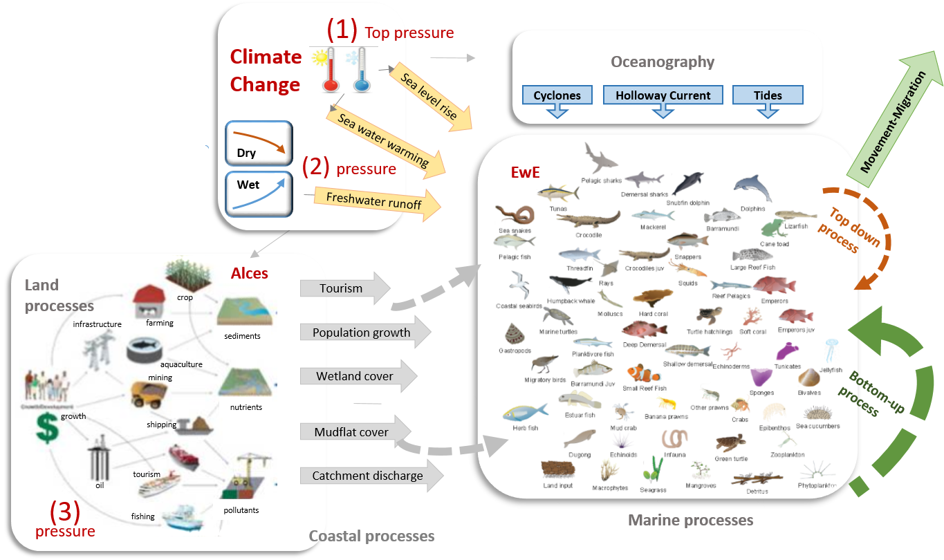 |
Figure 1. Conceptual model of the Alces and EwE models and their interaction |