|  | The Model DomainsA model domain represents the geographical area covered by  the model. The borders of the domain thus discriminate between what spatial  features are ‘internal’ or ‘external’ to the model. The choice of the model  domain thus reflects what we treat as internal and external to the Kimberly  system. This choice is problem-specific. It depends on type of questions we  need to answer and what processes are relevant to those questions.  It also depends on technical issues related  to the characteristics of the models we use, the computational effort they  require and the level of model complexity we are willing to accept. In addition, workflow constraints are critical. While  ideally we would like to be able to change the model domain according to how  the project develops and what questions become relevant when more information  is made available, in practise this is rarely possible, since all model  implementation steps depend on the model domain. As a result this choice has to  be finalised early in a modelling project.
 Here we describe the domains of both EwE ad Alces models and  the reasons why these domain shave been chosen.
 
 Ecopath with Ecosim
    
      |  |  
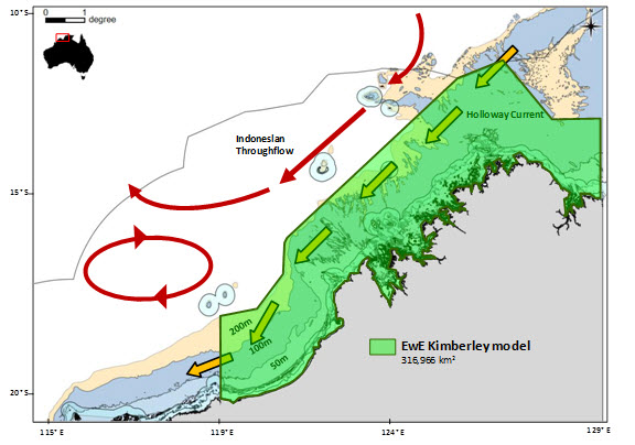
      | Figure 1. The EwE Model Domain |  Figure 1 shows the EwE model domain. The rationale for this  choice is more easily understood by analysing both the bathymetry and main ocean  currents as in Figure 2 below.  
    
      |  |  
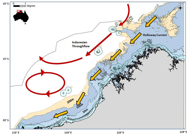
      | Figure 2. Bathymetry and main ocean currents over the Kimberley region |  
 
    
      | Model Boundary | Rationale |  
      | North. It roughly follows  the 200m depth  contour | 
      It contains surface currents (Indonesian Throughflow;  ITS) and seasonal currents (Holloway current) relevant for a better  understanding of annual and inter-annual variability (ENSO/La Niña years) of  primary production in the region. The ITF and  Holloway currents are related to the productivity of the Kimberley. For  example, when the ITF is weak (El Niño events), the thermocline (60-100m depth  on most areas) lifts bringing nutrient-rich waters into the photic zone and  hence resulting in conditions favourable to increase primary productivity.   Seasonal variability of primary production due to wind  and tidal actions occurring between 20-60m depth waters is considered. Some  internal waves (which raise generally more nutrient rich water) occur at  80-100m depths in the Kimberley region. |  
      | West.  119°E, southern end of the Eighty-Mile Beach) | 
      
      This area  contains more than 200 km2 of mudflats that are recognised as some  of the most productive in the world, supporting an extraordinary rich benthic  invertebrate community and one of the largest aggregations of shorebirds in the  southern hemisphere. This section of  the model domain includes not only migratory birds, but also dugongs, turtles  and sawfish. Humpback whales are sometimes seen in this area during their  northern migration to calving grounds further along the Kimberley coast. The Australian  endemic snubfin dolphin (Orcaella  heinsohni) inhabits this region.  The  extensive mangrove communities (north of Eighty-Mile Beach and Roebuck Bay)  support important nursery areas for prawns, mudcrabs and fish.Tourism and  recreational fishing activities may increase in this area. |  
      | East. Joseph Bonaparte  Gulf, border with the Northern Territory. | 
      This region is characterised  by its smooth bottom floor covered by soft,  muddy sediments, which is significantly different from the rest of the  Kimberley system. Important influence of the ITF (warm and oligotrophic  waters).The Holloway Current has a presence here at the end of  the Northwest Monsoon and also comprises surface waters at other times of the  year.Internal tides occur in this region, they are  associated with upwellings. Commercial prawn fishing occurs here.Dugongs are known to be present and associated with  seagrass communities in the inshore waters of the Gulf (i.e. waters <10m  deep)) |  
 AlcesComing soon.. 
 Other Maps
    
      |  |  
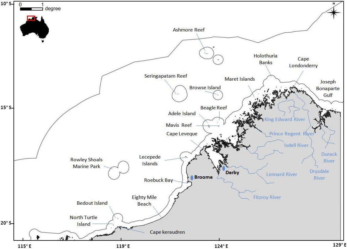
      | Figure 3. Main geographical features of the Kimberley region |  
 
    
      |  |  
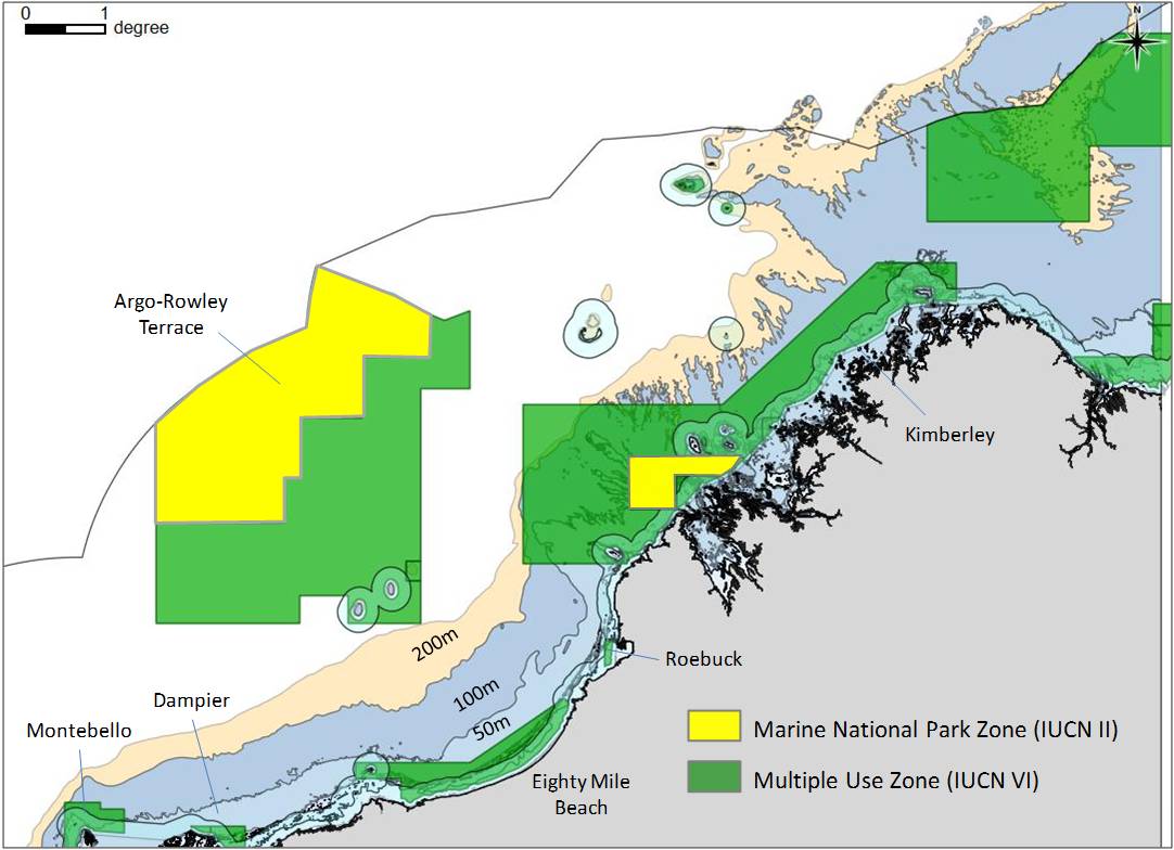
      | Figure 4.Marine Parks and Multi-use Areas |      |