Project title: Knowledge integration and Management Strategy Evaluation modelling
Program: Kimberley Marine Research Program
Modelling the future of the Kimberley region
About ALCES
Alces Online (www.alces.ca) is a landscape/landuse simulator used by the Alces Group and its clients to explore past, present and future relationships involving land uses (residential, transportation, croplands, livestock, mining, oil and gas, forestry, tourism/recreation) and natural disturbances regimes (fire, insects, landslides, storms, climate, climate change).
ALCES Online is a web-based GIS and simulator designed to inform strategic planning through the analysis and visualization of ecological and economic data. The tool increases the accessibility of spatial analysis and simulation modeling through a user-friendly interface and an integrated GIS and simulation environment. The tools database architecture and adoption of current technologies such as WebGL provides the performance to accommodate complexities of land use planning such as large study areas at fine scale spatial resolutions (millions of cells), long time horizons, and multiple drivers and indicators while still delivering rapid results. A published overview of the structure and function of Alces Online can be viewed here.
A general tutorial of Alces Online for the Kimberley region can be accessed here.
A synopsis of Alces application to this specific project can be found here.
ALCES in this project - Kimberley Alces Online (KAO)
The ALCES component of the project functions to model terrestrial landuse and landscape dynamics and interface with the marine ecosystem dynamics (EwE) to generate output on how these ecosystems interact and change over time. The primary purpose of the ALCES model is to track the key 1st-order dynamics of terrestrial land uses and landscapes, and to generate output that is relevant to the interface between terrestrial and marine ecosystems in the Kimberley Region. Put simply, how might historical changes, and proposed future trajectories, in human populations, settlements, mining, energy, croplands, livestock, tourism, and transportation, affect (directly, indirectly) key performance indicators being assessed in both the terrestrial and marine components. Using EwE, detailed marine dynamics have been addressed by CSIRO team members. It has been the responsibility of ALCES to generate and provide spatial and temporal information on land use and natural disturbance regimes that could be incorporated into the marine dynamics explored within EwE. A simplified IHD (impact hypothesis diagram) describes the key modules within the ALCES model intended to capture the key dynamics of the Kimberley system (Figure 1).
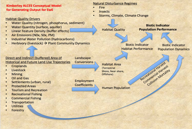 |
Figure 1. Simplified impact hypothesis diagram (IHD) describing the key components of the Kimberley Region system. |
A key contribution of ALCES to the WAMSI project is its ability to look both back and forward in time. Based on user-defined future trajectories for each land use in the Kimberley (mining, energy, aquaculture, commercial fishing, crops, livestock, settlements, tourism, transportation). ALCES simulates the growth (and reclamation where appropriate) of all relevant footprints for each land use trajectory. Since not all stakeholders will share similar beliefs in the pace and distribution of future land use growth, it is important for the simulator to be able to adjust quickly in response to different scenarios.
The Kimberley Biophysical and Land Use Atlas
To assist in the customization and attribution of KAO, a biophysical and land use atlas of the Kimberley region was prepared. This atlas contains several hundred map themes relating to physical, biotic, land use, and cultural themes. Of the ~900 different physical, biotic, and anthropogenic data themes that were loaded into Alces Online for the Kimberley region, 450 were mapped in high resolution and compiled into an archive called A Biophysical and Land Use Atlas of the Kimberley Region. This Atlas was prepared for use by the WAMSI project, the Kimberley Development Commission and the Broome Growth Cluster. This Atlas, prepared in MS PowerPoint, is formatted such that users can quickly navigate through and find different map themes. Project stakeholders can familiarize themselves with the Kimberley Atlas so as to better understand the datasets that inform the simulator. By using these spatial datasets that define the presence and proximity of both natural and anthropogenic features, Alces Online computes probabilities that define the temporal and spatial aspects of future land use footprint growth. An online version of the atlas is available for download here.
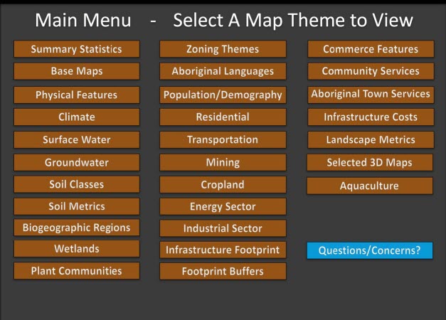 |
Figure 2. Main spatial categories within the Kimberley Atlas. |